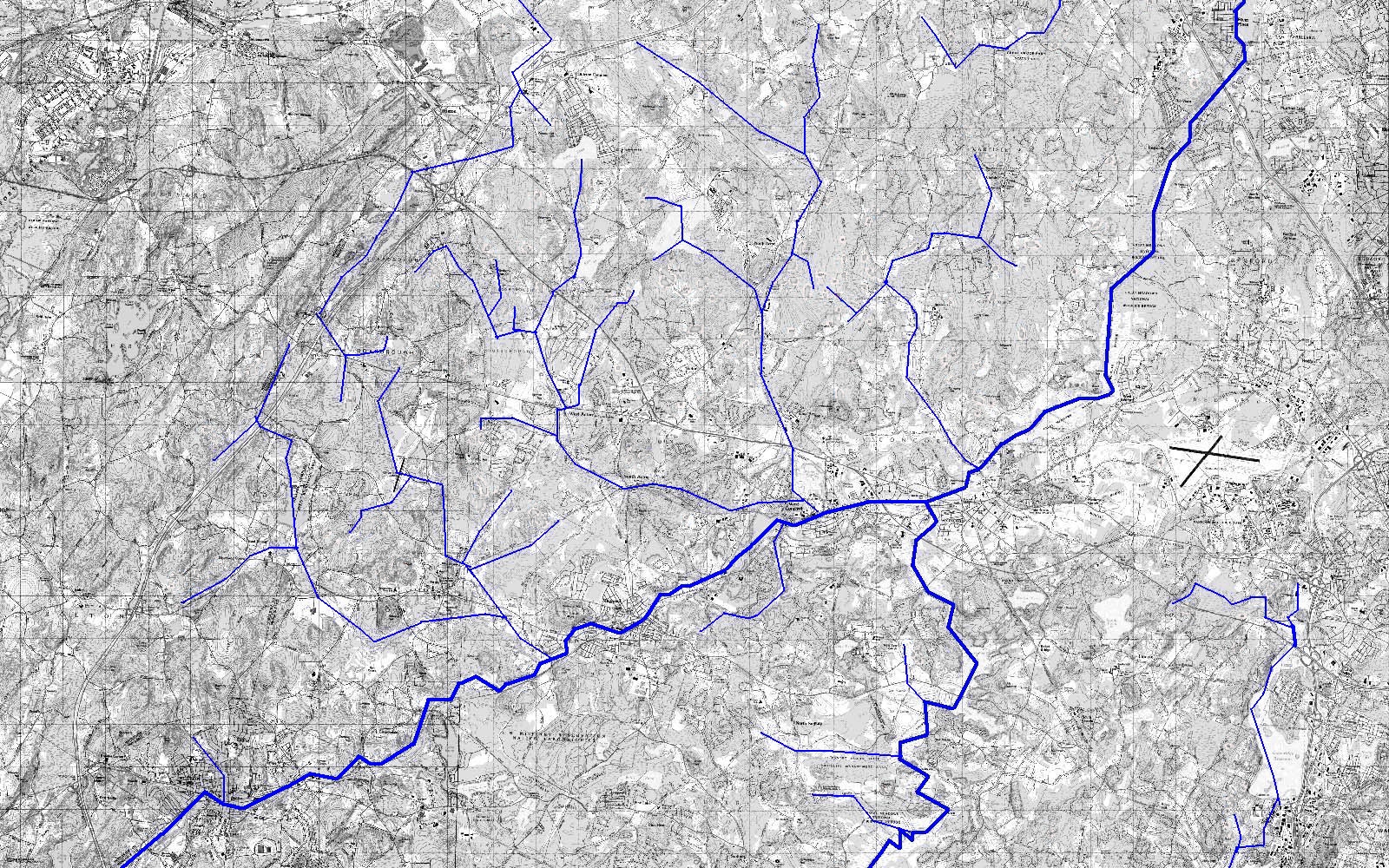
This map is a composite of the Maynard, Billerica, Ayer, and Hudson quadrangle maps from the US Geographical Survey. It shows a portion of Middlesex and Worcester counties of Massachusetts. During the years from 1998 to the present, in 2005, I explored systematically in this area locating rock pile sites. Major rivers and brooks are shown in blue. The Sudbury River in the south and the Assabet River in the west, join to form the Concord River which flows northeast.

The topographic map was used to identify forested areas, which were then explored. I learned that rock pile sites are most often found where hills meet water. This made it more efficient to find sites where these conditions were met but, over time, I also looked in other areas.
The topographical maps are divided into 1000x1000 meter square units. A count of the number of units visited versus the total number gives an estimate of the percentage of the region that has been explored. It is worth distinguishing between forested and un-forested units. Typical un-forested units are ones with residential or commercial zoning. Visiting un-forested units was not a priority and, in many cases, was not possible because of limited access to private property. Some example tallies are:
Other parts of the region have similar tallies. North of the rivers the coverage for forested units was around 75% or better, while south of the rivers the coverage for forested units was closer to 63%. The large number of private estates, and small amount of conservation land in places like Lincoln, substantially reduce the coverage and correspondingly reduce the information available for such towns.
I have explored outwards from Concord but not equally in all directions. I have not finished exploring in Sudbury, Natick, and other towns to the south. To the east, inside Route 128, there are fewer conservation lands and too few forested units. So sites are under-represented in these directions. This explains some of the difference between the upper and lower parts of the map, however I believe the uneven site distribution reflects a real difference in land use, not just a difference in sampling.
Let me call attention to three groups of sites on the map.
There are very few sites between the Assabet and the Sudbury. Although more exploration is certainly possible in this area, essentially no rock piles have been found there.
More than 140 sites have been found. Here is a trend chart of number of sites found per month. At the beginning I located one or two new sites per month. Later, during the summer of 2004, after learning how to locate them, they were found at a rate as high as three a week. The monthly information was not properly recorded pre-2000 or from June 2002 - June2003 so there are anomalies in the chart around Jul-98 and Jul-02. In spite of this, the increase over time is clear and suggests a learning curve.
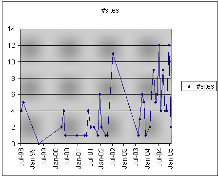
The presence of the learning curve makes sense - I was learning how to identify certain combinations of features on the topo maps before going out to explore, and also was learning where to look once there, in the woods.
Careful examination of the details of the map above show how the sites are related to hills and water. In particular, the majority of the sites are located where water comes out of the ground and begins to flow away downhill. Less frequently, sites are located on shoulders of hills, especially ones with southern views over water. Such conditions can be identified on a topo map even for areas that have never been visited. To illustrate this, here is a random piece of topographic map, from west of here, with likely places for rock piles circled. In the red circles, associated with water coming out of the ground, smaller rock piles built on support rocks are expected. In the blue circles, associated with southern views over water, larger piles built directly on the ground are expected.
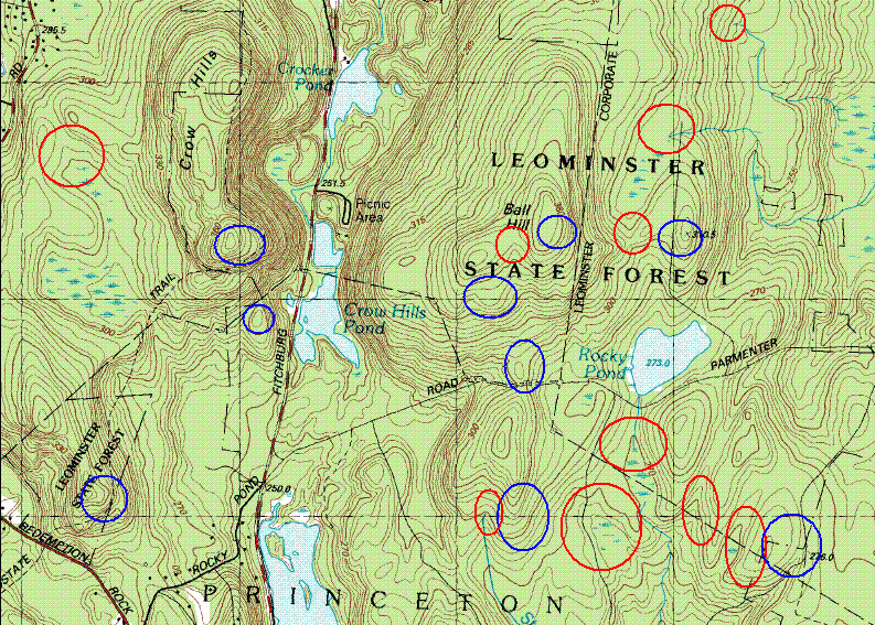
This is a part of Leominster State Forest, where I had never been.
To test this statement, and it being a nice day, I went out and explored in this area above the "C" in "Princeton" on the map. In the snow, fewer things are visible and it is hard to cover much distance but I found at least two larger ground piles looking out southwest over Paradise Pond (the lake under "I" in "Princeton"). These fit the expectations of the blue circles. I also found a pair of piles near a run-off gully, built on support rocks. These fit the expectations of the red circles. Here are example pictures from Leominster State Forest.
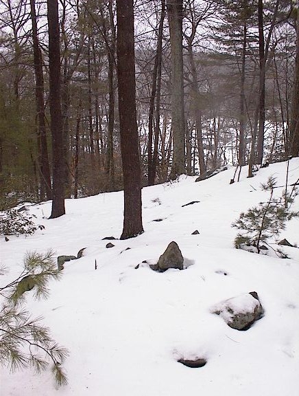
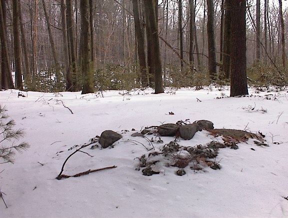
The first picture is a typical "blue circle" pile and location. It shows a marker pile with one central "marker" stone above a southwestern view over a pond. The pile is on the ground, reasonably large, and rectangular. The second picture is a typical "red circle" pile and location. It shows a small pile with a handful of cobbles on a support boulder. A few feet to the southeast is a dip in the ground which provides a channel for run-off water. I did not get to the exact locations I had made predictions for but applying the principles did lead to finding rock piles nearby. We might issue a challenge to field clearing proponents: to find a rock pile site in the snow, a half an hour drive away in an unfamiliar town - in less than an hour.
One of the most interesting observation about the site distribution is that rock pile sites are concentrated in rocky upland locations which were orchards, pastures, or swamp-land. In particular, where field clearing never occurred. We conclude that not only are rock piles not just the result of field clearing, in some cases they were probably even destroyed by agriculture. The actual site distribution is so much the opposite of what would be expected based on the field clearing theory, it is hard to believe its proponents (1) ever came in contact with more than one or two actual sites or, if they did, that they have reported them accurately.
Examples from Concord are instructive. Concord, with its fertile soil, probably had the most farming of any of these towns; yet it has far fewer rock piles than the less agricultural towns to the north like Carlisle and Acton. The largest rock pile site in Concord, on Annursnac Hill, occurs several hundred feet uphill from lowlands which might have been plowed. Another significant cluster of rock piles in Concord occurs along a ridge uphill from Willow Guzzle Brook. Why would anyone carry rocks uphill to dispose of them? A third site in Concord, is located twenty yards into a swamp near one edge of Estabrook Woods. A field could have been located nearby but why put piles in the interior of the swamp rather than at its edge? There is no need to look hard for answers. The field clearing hypothesis is simply not consistent with most of these sites.
To be fair, a number of fields were cleared into rock piles. This is seen at Great Brook Farm in Carlisle and at Weatherbee Conservation Land in Acton. At these places there are rock piles near the edges of fields. Ironically, these sites have well defined characteristics which make them easy to distinguish - with poorly made piles made of poorly sorted glacial till all scattered around the edges of the plow-able land. Before anyone ventures opinions about the nature of rock piles in general, they should acquaint themselves first-hand with known field clearing examples. How they differ from the sites in the uplands of Acton, Carlisle, Boxborough, etc will then be more obvious.
As mentioned earlier, rock piles are most frequently found where hill meets water. For example, a spring on a hillside is a very likely location of a rock pile site; or a place where a hill descends into a swamp. By their nature, such places are poor areas for farming. Rocky hillsides and swamps were not plowed and often rock piles are found far from any field which might have been cleared. This evidence is perfectly straightforward. That it is not understood by authorities in Massachusetts responsible for protecting sites is a scandal.
Once these sites are recognized as having a great deal of particular structure, highly organized and consistent with landforms where they occur, then it begins to seem likely they are Native American and similar to mound sites found throughout the east and the southeast (2). That this window into the ceremonial life of natives in Massachusetts would still be available, in spite of farming and other efforts to erase its presence, is good news for anyone interested in a deeper understanding of the Indians of this region.
(1) Letter to Phyllis Zinicola, Benfield Task Force, Carlisle Mass.
from Brona Simon, State Archeologist, Mass. Historical Commission
(January 18, 2005) which reads, in part: "MHC understands that the
project area is part of a larger parcel that was the subject of an
archeological assessment conducted by Alan Leveille of PAL in 2002.
Upon review of Mr. Leveille's report, a copy of which was included with
the PNF, MHC concurs with his conclusions that the stone piles found in
the Benfield property are most likely the result of agricultural land
use dating from the eighteenth through early twentieth centuries."
(2)
Investigation of Two Stone Mound Localities, Monroe County, Georgia.
Richard W. Jeffries and Paul R. Fish (1978) University of Georgia
Laboratory of Archeology Series, No. 17.