Fig 1
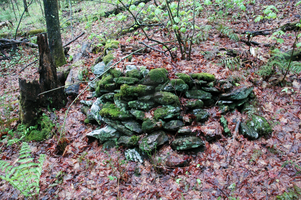
Fig 2
On a wooded hillside in Rochester, Vermont, at an elevation of 1900 feet, lies the abandoned farm of C.M. Smith and his son, who worked the 250-acres from 1847 until 1917. The cellar holes of the farmstead and barns can still be seen, now obscured by brush and surrounded by a growth of hardwoods and softwoods, which now also cover the fields and slopes that were tilled for crops. The property is now part of the Green Mountain National Forest and protected from development.
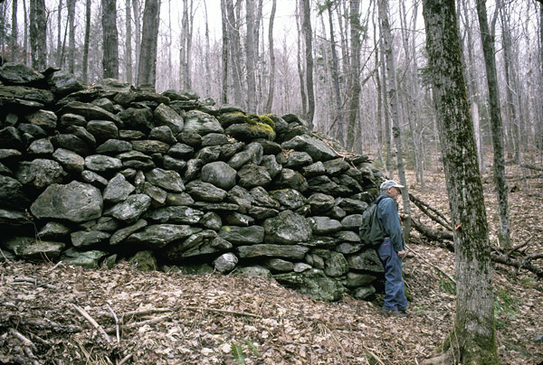
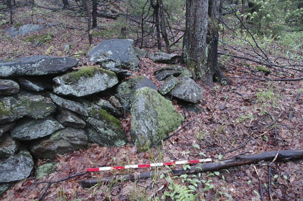
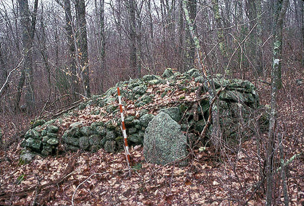
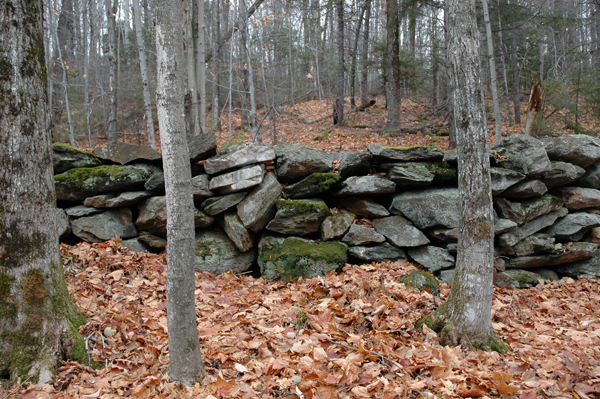
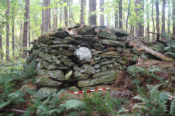
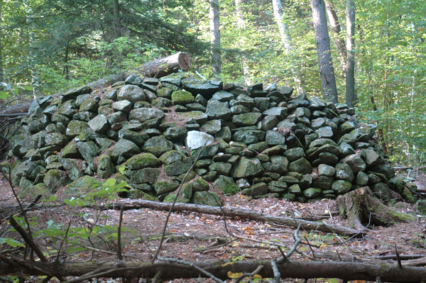
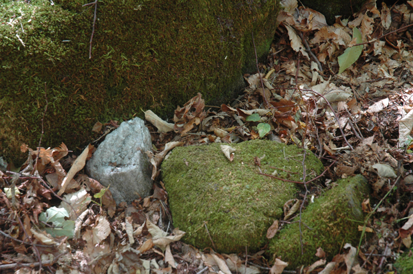
The most impressive and tantalizing aspect of the Smith farm are the more than 150 cairns and stone constructions spread out over an area of 50+ acres, mostly on the steep and undulating wooded slopes above the farm foundations. Some of the cairns are massive, measuring 40 feet or more on one side, such as one which shows Ernie Clifford, who guided me to the site nearly five years ago, standing alongside it to the right (Fig. 1). This cairn is a good 7 feet high on the downward slope. Others can be quite small, such as this terraced construction built against a slope (Fig. 2). There is no one size or shape. Go in just about any direction and one will come across a cairn that will truly be exceptional and amazing.
By far, one of the most impressive, unusual and intriguing features has to be a large, crescent-shaped cairn on the upper slopes of the site. Some refer to it as the "boat", but since there is no large body of water nearby, I prefer the term crescent, as in crescent moon, or perhaps an Indian bow. Measuring 37 feet long by 9.5 feet wide and 3.5 feet high, it has a bowed, crescent shape when viewed along its axis, with the convex side facing east (Fig. 3). When I first saw it, it reminded me of a crescent-shaped structure I had seen at Parker Woodland in Rhode Island, which also faced east (Fig. 4).
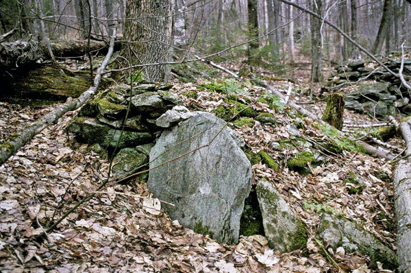
This feature, however, had a tapered backside and did not have any other distinguishing features. At the northeast end of the cairn in Rochester, and separate from the rest of the construction, is what I and others refer to as a Manitou stone, which in this case is a thin slab of stone with a rounded top (Fig. 5). Manitou stones either can be in the shape of an early American gravestone, with head and shoulders, or they can have a simple arched or triangular-shaped top; in any event, all examples are quite thin. Similarly shaped stones have been found alongside large cairns at other sites, such as at Parker Woodland in Rhode Island (Fig. 6), and also at least three other cairns at the Smith site, one of which is fairly small but with a Manitou stone leaning against it (Fig. 7). We do not know the significance of these stones, but they seem to emphasize the importance of the stone mound or cairn against which they are placed.
It is one thing to claim that an unusual looking stone feature is American Indian, simply because of its size, shape, construction, and how it relates to other stone structures nearby, and another to prove it. There is no direct way to date stone cairns to the accuracy that we need, but there are ways to use evidence to formulate sound arguments. For example, we know more about the Smith farm historically than we do about most sites with cairns. Before Smith bought the 250-acre property in 1847, it had been previously owned by at least five different individuals, beginning with a Peletiah Morgan in 1780, the original proprietor. With no access to it during the early years of its ownership, the property passed from owner to owner with its value fixed not much above $50. In 1812 it sold for $62. A year later, the property was bought by Alexander Norton for $184, triple the amount of the year before. What happened? I believe the sharp increase in value can be explained by the construction of a cart path from Brandon Gap Road to the property sometime in 1812, and perhaps the clearing of some land. This cart path shows on early 20th century maps of the area as a dotted line that ascends the ridge to the farm site. There was no other road to the farm, and it remained isolated from others in the area. Not until the 1930s, when the Civilian Conservation Corps cut a road through the forest did the old farmstead come into closer contact with contemporary society, but by that time the farm had long been abandoned. After Norton purchased the land in 1813, it was sold three more times until Chester Smith assumed ownership in 1847. In the book Rochester, Vermont, Its History, published in 1975, the unnamed authors wrote that only four acres had been cleared when Smith purchased the land.
Letters that Chester wrote to his fiancee, Sarah, between 1848 and 1850, describe some of the activities in those early years at the farm. In one letter, from February 1848, he describes felling 300 trees that were then hauled to a mill on Brandon Gap Road to be sawn into planks for the construction of a house and barn, and clearing 30 acres for mowing. Remember that only four acres had been cleared when Smith moved to the property in 1847. Add to this the 30 acres in 1848 and we still have a total of 34 acres cleared, much less than the 50+ acres on which the cairns are found. This evidence implies that some of the cairns, at least, must have been pre-existing before the land was first sold in 1780. Add to this information derived from the Smith daybooks from the 1840s to the 1880s, in which there is absolutely no mention of constructing stonework of any kind, and we have a pretty clear picture that neither Smith nor any of the previous owners of the property constructed the stonework.
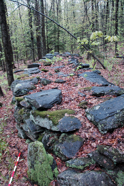
Not much attention has been paid to the planning and construction of a large cairn, such as ones found at the Rochester site. Several years ago I chose a large one at the Smith site to determine how many stones comprised it. The cairn measured something like 21.5 feet long, 8" high on the downhill side and 12" wide (Fig. 8).
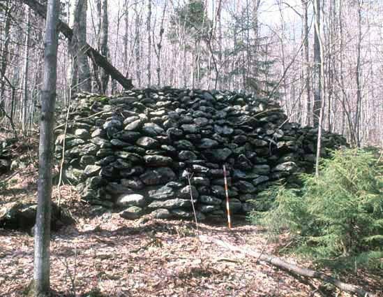
I measured the sizes of different stones in the facade, and gave this figure to a friend of mine in Wisconsin, Herman Bender. Based on figures I provided, he estimated that there were something like 10,000 stones of various sizes in the cairn, which altogether weighed 80 tons. Photos of the cairn and the stones, plus the figures from Herman, were sent to Nick Aiken, a professional dyker or wall builder from Scotland, in October 2003. Here is what he wrote about constructing a cairn of this size: "The stones must have been brought to the site. There are too many in each cairn to be found in the immediate area. If I were building such a structure I would spend the winter hauling stone over the frozen ground, on a sledge. It would take some time to get 80 tons of rock to the site -- April is "mud season" in Vermont. I believe it is usually May before the ground is stable and it is easy to move around without getting stuck in the mud. The big rocks at the foot of the cairn must have needed two men to shift them. It would not be impossible for one man to do the job but he would have been ruined in a short time. I can shift about 5 tons of stone in an easy day. I think I could build number 13 in about three weeks but the hauling of rock might take all winter. One man hauling to the site would take a soul-destroying amount of time. The rock may have been hauled to the site as it was required, large rocks first then the smaller stuff. I would move rock from near the top of the slope down to a chosen spot, thus reducing the need to haul uphill."
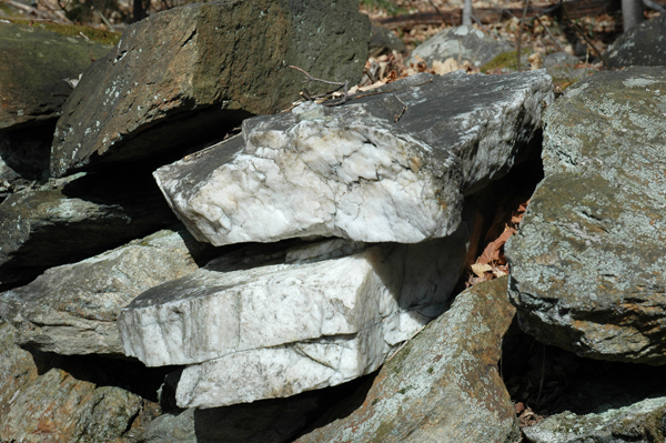
Besides the work involved in building a large cairn, we also need to look at the kind of stones used in its construction. With respect to the crescent cairn, in the very front center of the cairn, and placed on top, are two large slabs of quartz (Fig. 9). An enlarged view shows that each slab is about 5"-6" thick and cleaves horizontally (Fig. 10).
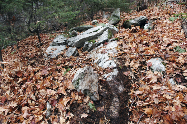
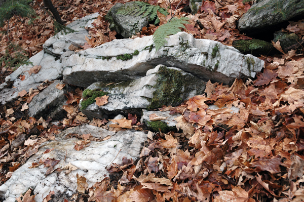
About 150 feet to the southwest is a large quartz vein or seam (Fig. 11), at the downhill end of which a spring emerges. The physical characteristics of the quartz, with thick, horizontal bedding planes, are identical to the slabs on the cairn (Fig. 12), and the latter undoubtedly came from this location. The fact that a spring emerges from one end of he quartz vein makes this particular site powerful and sacred, for springs were considered portals to the underworld by the Indians, where animal spirits emerged and went. This sacred water also imparted to the quartz extra potency, and we can imagine that the quartz from this location was chosen for this reason.
Although some may say that early Vermont farmers used quartz as aesthetic accents to stone mounds, the identification of quartz with the American Indian makes a much more convincing case. Milky or clear quartz crystals were sought by the Indians because of their purity and symbolic connection with the sun; to some, quartz was considered solid light or even the sun's semen. David Whitley, a rock art expert, wrote that quartz crystals were believed inhabited by spirits and thereby contained supernatural power that could be received and used for various purposes. Also, quartz crystals were considered living or live rock, which made them powerful to Indian shamans, who would often carry the crystals with them on vision quests, breaking them up so that the supernatural power in the stone would enter their bodies and enhance their potency. But quartz also had another unusual physical characteristic in that if one rubbed two quartz pieces together, they would emit a photon light called triboluminescence. Quartzite will also do this, but not to the extent that pure quartz will. The Indians certainly knew of this, and chose quartz for this reason.
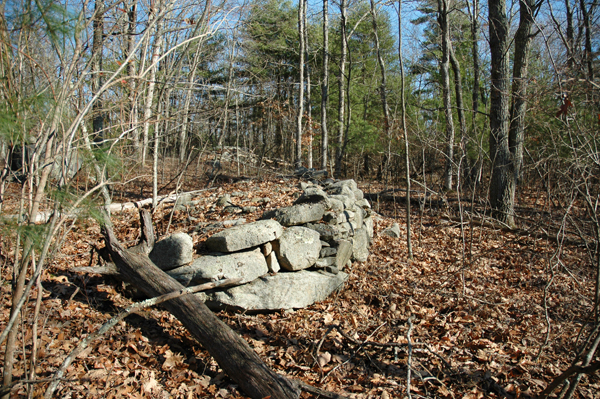
If we look at the use of quartz with this in mind, the large, round, prominently placed quartz cobble in the center of a large cairn in Stockbridge, Vermont, ten miles south of Rochester (Fig. 13), can be viewed as a culturally induced accent, and hardly one that a colonial farmer would have made. The quartz cobble faces north and is not an accidental placement, especially when one considers how all the smaller flat rocks have been piled around it to keep it in place. Similarly, forty miles to the southwest of Stockbridge in South Newfane is another cairn location, where again we find another large platform cairn with a quartz cobble prominently placed in the center, also facing north (Fig. 14).
Interestingly, this cairn has a short stone extension some 6 feet long at one corner, as does the cairn just mentioned at Stockbridge. And going back to the Oley Hills site in Pennsylvania where this research began ten years ago, Platform B also has a tail at the northwest corner (see Row-Linked Boulders Site, Oley Hills and Figure 1). At the same site in Newfane is another cairn, this one 24.6 feet long and not as high, but again with a piece of quartz placed in the very center (Fig. 15).
As we have already seen, quartz transmits energy, and it is this unusual and important characteristic that can be used to explain its function in an unusual split boulder arrangement found in a mountain gap just outside South Pomfret, Vermont. Here, a large boulder split down the middle, and over the centuries gradually spread apart. A semicircle of stones was then arranged at one end of the split boulders, connecting the two together (Fig. 16). All of the stones comprising this semicircle, except for one, are probably gneiss, and that one exception is quartz, which was placed adjacent to the left boulder (Fig. 17). I view this construction as something akin to an electric cord, in which energy is transmitted from stone to stone along the semicircle, but it is the quartz that imparts much more energy or juice, similar to plugging a cord into a light socket.
We have not yet reached a stage where we can say what the purpose of the cairns served. Their construction was certainly labor intensive, and many of them can be classed as monumental. The crescent cairn in Rochester is one of the most unusual, and certainly one of the best preserved. The location of the quartz slabs in the center must certainly have had something to do with the fact that they point in the direction of the rising sun. Furthermore, it is an impressive construction, not only because of its shape and size, but also because of its workmanship and artistic qualities.
Copyright 2007 by Norman E. Muller