Contact the coordinator at NH-coord@neara.org
The New Hampshire Chapter is where NEARA began. Back in 1964 a group of like-minded antiquarians came together to share a passion for the enigmatic lithic structures they were finding in the New Hampshire woods. NEARA was born! Not too much later, the first woman joined their group, as did interested parties from the other New England states. New Hampshire is still a hub of activity for the NEARA, although members now join from world wide locations. After all New Hampshire is home to Mystery Hill (America's Stonehenge), the Madison boulder, and the mailing of the Transit and Journals.
Please join the current day NEARA researchers as they tromp over hill and dale in search of that odd stone formation and verify that it is truly engimatic when they do deed research and find no recorded deeds!
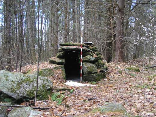
Chambers, small stone buildings of indefinite function, dot the hilltops and roadsides of New Hampshire. Some believe they are the remains of colonial root cellars. Others argue that they are Native American ceremonial structures or Celtic in origin. Some New Hampshire chambers are listed below.
Located on a hilltop in Acworth are many small enclosures and stone rows that have excited the curiosity of people for the last century. William Goodwin’s 1947 book History of Great Ireland in New England compared the site in Acworth to similar sites in Europe and hypothesized that the chambers and stone rows were built by Irish monks settling the northeast centuries before the arrival of Columbus. Later ideas claim different functions for the site, including Native American ceremonial structures, colonial storage chambers, and the remains of fox hunting traps.
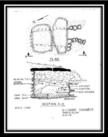
The Danville Chamber is relatively easy to find and is, at this time, accessible to the public. Follow Route 111A to Hersey Road. Hersey Road bears sharply to the left. Follow it to the end and park out of the way of the DPW facility access. Walk down the dirt road and look for a trail to the left; follow the trail along the bedrock outcrop and look for the chamber built into the side of the hill.
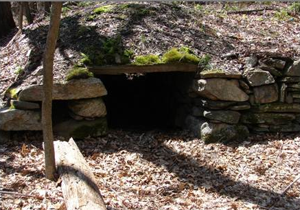
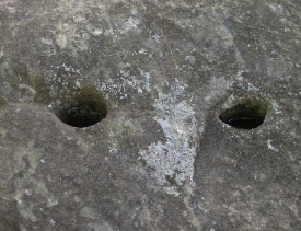
The Derry chamber is located along an abandoned railroad track in Derry and most likely of modern construction. Look for drill marks along the rocks at the bottom of the interior of the chamber.
To get to the Derry chamber follow Windham Road in Windham to Windham Depot Rd. Turn onto Windham Depot Rd and look for rail trail parking immediately on your right. Once out of your car follow the paved area to the rail trail head. DO NOT follow the main trail, but look for an unpaved side trail off to the left. Follow this trail for 0.2 miles. The chamber will be immediately off the trail to the left.
Most of New Hampshire’s unusual rock formations are known to be natural; some argue that these formations are the work of early man. Glaciers have rearranged these heavy stones so that they appear in almost impossible-to-believe formations. Man, however, may have also enhanced the work of nature.
Perched boulders, also known as balanced rocks, are places of natural beauty that capture the imagination of many today and may have been significant to New Hampshire’ first inhabitants. Perched boulders in New Hampshire may be found in Andover, Antrim, Pillsbury, Raymond, and Woodstock, as well as in other places around the state.
Early accounts of New Hampshire include many descriptions of “rocking stones”, boulders that move easily on their base when pushed or disturbed by the wind. The most famous of these, the Durham rocking stone, is described below:
“A large detached block of granite, in the south-east part of this town, was formerly placed in a very singular situation. Its weight was sixty or seventy tons, and it was poised so exactly upon two other stones, as to be visibly moved by the wind. It was some years since dislodged from this extraordinary position by the barbarous curiosity of some visitors.” Hayward, John. A Gazetteer of New Hampshire Containing Descriptions of All the Counties, Towns, and Districts in the State. John P. Jewett: Boston, 1849.
Other rocking stones have been described in historical records in Andover, Goffstown, Hanover, Meredith, Newport, and Warren.
Most early historical accounts attempted to write the Native peoples of New Hampshire out of its history sometime in the Eighteenth century. Reduced by disease, driven away from their homelands and into Canada, or forced to assimilate, the Native population of New Hampshire seemed to disappear. Under these circumstances it became easy for many to claim that New Hampshire was never home to any substantial Indian population, a view that still exists in many parts of the state today.
If one looks closely, though, reminders of this vibrant and substantial culture can still be seen in woods and backyards throughout the state. Petroglyphs, grinding stones, and other stone remains are still being found and recorded. NEARA is attempting to do its part to preserve and document the remains of this once omnipresent Native New Hampshire below.
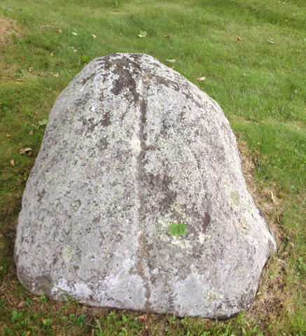
Pictures in stone are often hiding in plainsight. Look closely at large boulders or rockslocated in significant places and you may see one jump out from the shadows of the rock.
Cupules, circular indentations pecked or ground into bedrock or boulders, have long been associated with Native cultures of North America, and are found in several locations across the northeast, including New Hampshire. One of these sites is in Laconia at Endicott Rock Park.
The original charters of Massachusetts and New Hampshire stated that the border between these colonies was to be set three miles north of the Merrimack River. However, subsequent reports indicated that the Merrimack River ran north-south, not east-west, as first believed, and a border dispute between the states soon ensued.
In 1652 Governor Endicott pressed his advantage and sent members of the Massachusetts Bay Colony in search of the source of the Merrimack River. With the help of their Indian guides, these men made it to Weirs Beach, or Aquedocton, in Laconia, the site of a large Indian settlement, and carved their initials and the name of Governor Endicott upon a large rock in the channel of the Winnipesaukee River, laying claim to the surrounding land for Massachusetts.
Long thought of as a significant historic place, Endicott Rock has recently been reevaluated to include the cupules that mark its surface. These cupules, located on a prominent rock near a large fishing village, must have been significant to the Native community of Aquedocton and the guides who led the colonists to the source of the Merrimack River.
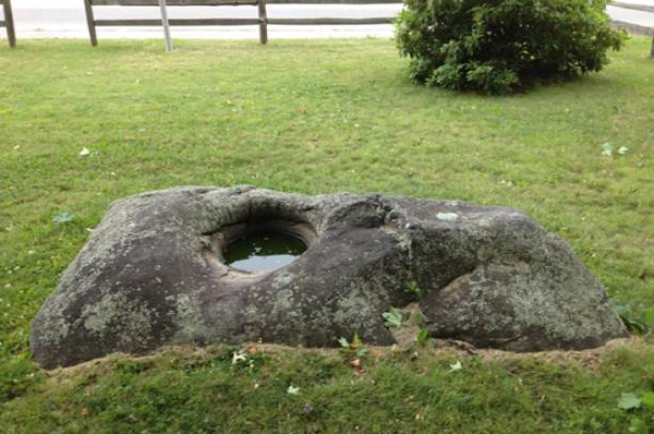
Grinding stones are believed to have been used by Native peoples to grind their corn. This one is located in Franklin at the corner or Dearborn and Central Streets.
Thorvald’s Rock, Hampton, NH
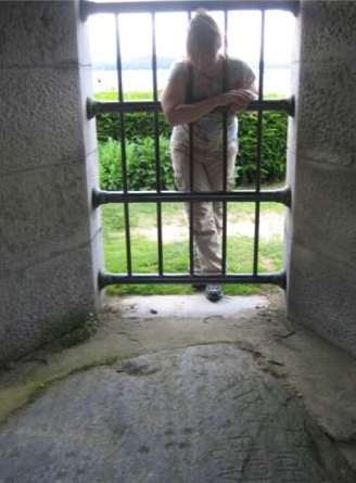
Across the street from the Tuck Museum in Hampton is a boulder covered with lines and scratches once thought to be a runic inscription marking the site of the burial of Thorvald, an early Viking explorer of “Vinland”. Encased in a concrete enclosure and set beneath iron bars, this rock was once so important to the residents of this town that it sparked the formation of the local historical society. Now debunked and widely thought of as a fake, Thorvald’s rock still attracts visitors to the Tuck Museum.
Hampton’s Lane Memorial Library is a great source for more stories on Thorvald’s Rock.
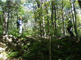
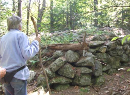
New Hampshire is the “granite state” and one is not surprised to come across stone piles while walking in the woods. Some are clearly the remains of long-abandoned farms. Others, located on land that no one would ever farm or built with obvious design, seem more mysterious. Are they clearing piles left behind on long-abandoned farms? Are they burial sites for early colonists? Or are these the remains of Native American ceremonial sites?
Our goal in NEARA is to document and preserve as many of these sites as possible until such time as we can determine their origins and functions. Please help us preserve them by reporting them to NEARA and by leaving them intact.
America's Stonehenge (Mystery Hill)
Great mapping tool that allows user to customize maps with different layers; sorry, but it only covers New Hampshire!
New Hampshire ArcheologicalSociety
New Hampshire County Registries of Deeds
Many of NH deeds are digitized and available to view online. If you prefer to vi the registries in person, directions are available on the website.
New Hampshire Historical Society Museum, Concord, NH
New Hampshire’s public archaeology program; find out information about upcoming field schools and training opportunities.
Find information about NH archival holdings or read all 40 volumes of the “NH State Papers”.
Stone Structures of Northeastern United States
Interesting interpretations on stones structures in the New England area
NEARA cannot give out addresses to many of the private sites in our archives, but here are some links to sites open to the public in New Hampshire that you may enjoy:
Who built this unusual site? Take a tour and decide for yourself.
Covered in Native American cupules and initialed by colonial explorers, the smallest of New Hampshire’s state parks figures prominently in the border battle between New Hampshire and Massachusetts.
Indian Mortar Lot Franklin, NH:
Located on the corner of Dearbon and Central Streets in Franklin, NH this small park contains an Indian mortar stone used by Native peoples to grind their corn in past centuries. Also look for the fish petroglyph on another boulder in the park.
Designated as a national landmark, this glacial erratic is purported to be the largest one in New England.
Supplement to New England Waterfalls: A Guide to More Than 400 Cascades and Waterfalls (2nd Edition). Countryman Press, 2010. Look for the remains of stone sites around waterfalls while you enjoy the scenery.
One of the natural wonders of New England, the boulder field of glacial erratics wedged inside this extinct volcanic caldera must be seen to be appreciated.
History of New Hampshire:
Old books on town histories are a great source of information about early sites in New Hampshire. The following books on New Hampshire history are available online through Google Books. You may read them online or download them as PDF files or to your e-reader.
The History of New Hampshire Volume III. Belknap, Jeremy. Belknap and Young: Boston, MA, 1792.
Out of print, but buy it on Amazon if you see it!
A great introduction to 10,000 years of New Hampshire archaeological history.
The Indian Heritage of New Hampshire and Northern New England. Piotrowski, Thaddeus M., Ed. Jefferson, NC: McFarland and Company, 2002.
A collection of historic and modern essays exploring the history of the Indians of New Hampshire as seen through the eyes of archaeologists, historians, and early European settlers in the state.
A Time Before New Hampshire. Caduto, Michael. Lebanon NH: UPNE, 2003.
A great book describing the natural history of New Hampshire and the lives of its earliest people.
When you find something in the woods and aren’t sure what it is, Robinson may know. Out of print, but buy it on Amazon.
Interpreting Land Records. Wilson, Donald. John Wiley and Sons: Hoboken, NJ, 2006.
If you delve into land records, let this book be your guide. Many examples from the text are drawn from NH deeds.
Many historic accounts of abandoned New England hilltop towns. Out of print, but available on Amazon.
A must have book if you spend any time walking in the woods.
America’s Stonehenge Deciphered. Gage, Mary. Mary Gage and James Gage: 2006.
Mary puts on her interpretive hat and gives a different view of the famous hill in Salem, NH.
Co-authored by Bob Stone, NEARA founding father and owner of Mystery Hill.