
Contact the coordinator at RI-coord@neara.org
Rhode Island may be a small state but it is rich in lithic features. Clusters of rockpiles are spread throughout its conservation lands, petroglyphs and runes are carved along its shores, and curiously propped boulders suggest that more than nature was involved in the manipulation of the stone-filled landscape.
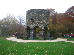
The unusual arched architecture of the tower gracing Touro Park in Newport has spawned considerable speculation on its origin and use. Historically known as the remains of a 17th century windmill constructed by Governor Benedict Arnold, alternative proposals have conjured up visits by Vikings, Medieval Norse, Portuguese, Templars, the Chinese and Basques. A nearby museum makes the case for a link to the Elizabethan navigator and astronomer John Dee.
Tom Elmore produced a video about NEARA's project to make a 3D LiDAR scan of Newport Tower:
Tom writes: "This video shows the first ever 3D LiDAR scan of the Newport Tower. Our scanner captures 300,000 points per second while we walk, and in this case while we lifted it up and back down inside the Tower in a non-invasive manner. The scans were registered together to include Touro Park and then georeferenced to 6 GPS points scattered around the Park."
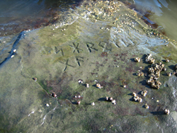
Long visible at low tide on the west side of Narragansett Bay, this boulder contained engraved characters resembling Norse runes. Although difficult to date or authenticate, some accept the stone’s engravings as evidence for pre-Columbian Viking exploration of Rhode Island’s shoreline.
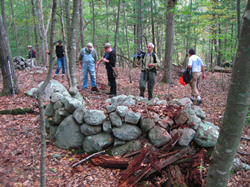
Clusters of stone piles can be found within the state’s conservation lands. Some may be remnants of Indian burial or prayer sites while others may be the result of field clearing. Perhaps analysis of the distribution of piles and research into historic land use may one day tease these theories apart.
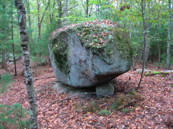
Glaciers may have left these large erratics perched in prominent locations, or perhaps they were jockeyed into position by prehistoric peoples. Either way, the pair of propped boulders peering from bedrock outcrops in Eschoheag create an impressive image.
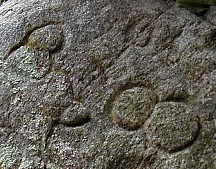
Deep furrows in a boulder on the Scout Reservation have been interpreted by some as Native American symbols, perhaps a tomahawk and arrowhead signifying a hidden cache of weapons nearby. But like so many of the other lithic features in Rhode Island, there are other possible explanations, from a pioneer engraving to natural erosion of softer veins in the stone.
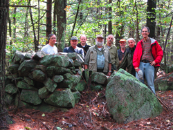
The Manitou Hassannash Preserve (MHP) in Hopkinton RI preserves over 1000 stone structures in 14 acres of rocky hillside.
Mary Gage has shared a video about the diversity of stone cairns found at MHP:
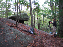
Tom Elmore produced a video about 3D LiDAR scanning at MHP:
NEARA had a webinar on using relatively new technologies together for recording, preserving, and exploring sites, including 3D LiDAR scanning at MHP. You can watch the recorded session at:
3D models of the somewhat worn petroglyphs on a beach in Tiverton are available for interactive viewing at Tiverton Petroglyphs.