Chuck Drayton has graciously allowed NEARA to host and update his stone sites website.
He has been visiting Foxboro State Forest for over 70 years.
Stone Sites in Foxboro State Forest, by Chuck Drayton
In the town of Foxboro, Massachusetts, there is a region of approximately 1027 acres of undeveloped forestland known as the Foxboro State Forest. For years, many people have used the rugged trails in these woods for hiking, mountain biking, horseback riding, and for simply viewing the unique characteristics of its scenic New England landscape. However, off the beaten trails and away from the old dirt roads, those that have "bush-whacked" their way across this terrain have discovered many unique man-made stone structures that clearly give evidence of cultures from another time period. Cultures that predate the town's incorporation date of 1778 by possibly thousands of years. Guesses as to the origins of these structures have ranged from the local native Wampanoag Indian culture, to Celtic travelers predating Columbus, to even prehistoric tribal cultures having a strong knowledge of solar and seasonal calendars.
The State forest area is one of the highest points of land between Boston and Providence, and is currently referred to by locals as High Rock. This "high place" characteristic, combined with the types of stone structures found in this forest, indicates that this region could very well have been considered a "sacred place" in the past, and that it was a regular destination for ceremonial purposes, spiritual cleansing and prayer.
THE PURPOSE OF THIS WEBSITE is to record and display data pertaining to the unique stone structures in the Foxboro State Forest, so the general public will be aware of their existence. This information will allow others to visit, speculate and form personal conclusions concerning who built them, why they were built, and when they might have been created. It is also a great hope that the information collected here will spark an interest in the archeological community, resulting in a true scientific study to determine their origins.
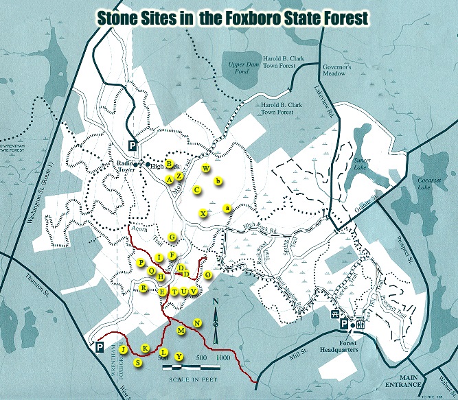
The most significant section of this website is its Forest Site Map. This page displays a Foxboro State Forest trail map indicating all the recorded stone sites marked for viewing. When a particular site is selected, a picture of the site is shown, along with its physical description and location.
WARNING: All sites recorded on this website may be visited. If you do decide to view these sites in person, please treat them with the respect they deserve. Do not replace or change the position of any of their stones. Do not climb on them, or deface them in any way. Many of these structures are very fragile and should not be touched at all. Please ... VISIT AND ENJOY, BUT DO NOT DESTROY.
The Foxboro State Forest contains a variety of "types" of stone structures.
These types have been broken down into the six categories below.
ALIGNED BOULDERS
A boulder is a very large stone, usually large enough to take more than a single person to move. Aligned bounders are when three or more of these large stones are placed in a straight line. Many times this line creates a near perfect north-south or east-west line. This possibly indicates the site's creators were very aware of solar markers indicating compass direction. Also, the distance between the boulders is often within a few inches of being identical. This uniformity could be an indication that from a given point, equinox or solstice readings may have been taking place.
DOLMENS
A dolmen is a large flat stone resting on three or more smaller stones. Uses might have been as a special marker signifying a "special/sacred" spot, a sacrificial table, or possibly a part of a series of multiple stone objects. The Foxboro dolmen is in very close proximity to a group of four very large aligned boulders forming a perfect North-South line. From the dolmen, each boulder forms a line pointing to the horizon in the east. Possibly these are sunrise points indicating seasonal changes or longest/shortest days of the year.
STANDING STONES
Single tall narrow stone, obviously man made, propped up to be a marker or directional pointer of some kind. These stones usually have a ring of smaller stones at its base to act as support. Early explorers may have used these as trail markers, early farmers may have used these as boundary markers for their land, or even earlier in history, these objects could possibly have simply indicated special events that took place at that spot.
PERCHED BOULDERS
A large boulder, supported partially, or completely, by one or more smaller boulders. The structures completely supported by three stones are the most impressive, and usually suppress any tendencies to attribute creation to glacial activity. Because of the size of the boulders involved, one might speculate that these formations were made to show others the strength (power) of a tribal leader to anyone who wandered into a their territory. Or possibly these formations were used in combination with others to show direction or pathways to solar/celestial events.
PRAYER SEATS
A horseshoe shaped configuration of rocks. Usually about 8 feet in width and 3 feet in height, always opening toward the north, and often built on an incline with the opening facing up the hill. Current traditions of the Yurok tribe in Northern California, who have Algonquin roots to our New England tribes, use prayer seats for spiritual cleansing by tribal medicine men and shaman. Days of fasting, meditation and prayer are believed to cleanse the soul. Sitting in the center of this formation facing the opening, the sun rises over the formation's right arm, sets over the left arm, and directs one's eyes toward the North Star.
STONE PILES
Just as the name implies, these are large numbers of stones piled on top of each other, in a specific location. In the Foxboro State Forest, a number of these piles have been found that mark locations that form a straight line. This would indicate a boundary of some kind or possibly a line pointing to a location. Single piles may indicate a "location of importance", possibly a burial location.